
The Netzknoten Navigator connects German road network nodes, sections, and stationing with GPS locations, coordinates, and an interactive map. Traffic control companies can search locations, convert professional road references back into real-world positions, share results, and process larger data sets. Professional capabilities also cover mobile field use, exports, APIs, and MCP-based integrations.
Which road-location tasks does Netzknoten Navigator bring together?
A work zone has one physical location, but that location can appear in several very different forms during the same project.
The tender may describe a road section and station. A project manager receives a map pin. A field employee works with GPS. A GIS specialist needs ETRS89/UTM coordinates. The crew leader simply wants a destination that opens in the navigation app on a phone.
Vextario Netzknoten Navigator is built for the transitions between these representations.
It is not merely a Netzknoten database and it is not another consumer map. The application treats the road location as one connected piece of operational information and provides tools to find, translate, inspect, share, export, and integrate it.
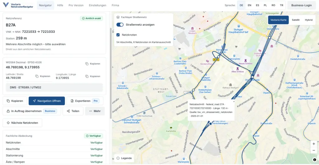
For companies that regularly work on German federal, state, and district roads, this combination is more useful than another isolated search interface.
Product page: Vextario Netzknoten Navigator
https://netzknoten-navigator.vextario.com/
How does a coordinate become a professional German road reference?
One of the most direct workflows starts with an existing geographic position.
A user can enter WGS84 coordinates, use the current GPS position, or select a point directly on the map. Netzknoten Navigator then evaluates that point against the available road-network data.
Depending on regional data availability, the result can include the road, relevant network nodes, road section, stationing, and additional road-reference attributes.
This becomes useful whenever a traffic control company receives a job only as coordinates.
Instead of opening a general mapping service first, identifying the road visually, and then starting a second search in a state road-information system, the geographic point becomes the starting point for the professional network reference.
The calculation also has to deal with situations that are more complex than simply selecting the nearest road line.
Interchanges, ramps, branches, and separated carriageways can create several plausible network relationships within a very small geographic area.
How can a road section and station be converted back into a physical location?
The opposite direction is just as important.
Road-authority documents, tenders, asset information, and existing project data often contain a road reference before anybody has a convenient latitude and longitude.
Netzknoten Navigator therefore supports reverse resolution.
A road, Netzknoten, section, and stationing reference can be translated back into a geographic position when the required regional source data supports that operation.
This makes a formal road reference useful to people outside a road-information database.
The office can inspect the point on a map. A supervisor can review the surrounding area. A field employee can open the same location on a smartphone and transfer the geographic destination to navigation.
This bidirectional behavior is one of the main differences between Netzknoten Navigator and a simple network-node map.
How does direct Netzknoten search help with incomplete project information?
Projects do not always arrive with a perfect coordinate or a complete stationing reference.
Sometimes the road is known but the section still has to be identified. Sometimes a document contains a Netzknoten but the surrounding network needs to be inspected. In other cases, the project manager knows only the approximate area of the future work zone.
Netzknoten Navigator allows roads, network nodes, and network sections to be searched within the same specialist context.
Available nodes can be displayed directly on the map. A selected map point can be evaluated against nearby road-network elements. Section geometries between nodes help the user understand which part of the road a professional reference actually describes.
This is particularly useful at interchanges.
A single visual road location may sit next to several branches and carriageways. Looking at the network structure together with the geographic map gives the user more information than a simple nearest-road search.
Which map capabilities are useful in the office and in the field?
The interactive map is the common workspace for many of the product’s functions.
In addition to the road-oriented map view, satellite and hybrid views can provide visual context around a work location. This can be helpful when the formal road reference is already known but the surrounding physical environment still matters.
A supervisor may want to understand the relationship between a project location and a nearby ramp, bridge, parking area, access road, or intersection.
The user’s current GPS position can be displayed together with the professional road reference when location access is available.
Office workflows do not depend on device location. An employee can select any point on the map, enter coordinates, or start from a road reference while preparing a project hundreds of kilometers away.
The application can also determine the relevant German state from the selected location, while manual state selection supports deliberate research in another regional data environment.
Why does the product need to understand regional differences in German road data?
Professional German road data is maintained through different road authorities and regional information systems.
The scale involved is substantial even within a single state.
At the end of 2025, Landesbetrieb Mobilität Rheinland-Pfalz was responsible for 17,384 kilometers of classified federal, state, and district roads. Its infrastructure portfolio also included approximately 5,700 bridges.
In Bavaria, 64 road maintenance depots provide operational services for federal and state roads. Approximately 2,200 road maintenance workers and related staff support the network.
A nationwide specialist application therefore cannot reasonably assume that one uniform source provides every attribute in exactly the same way.
Netzknoten Navigator treats regional capabilities explicitly.
When a source provides a specialist attribute, the application can use it. When reliable source data does not provide the required information, the product should not fabricate a convenient value.
For users, however, the interaction can remain consistent even when the underlying data environment changes from one state to another.
Which coordinate formats can be generated from the same road location?
A location can be correctly identified and still be represented in the wrong coordinate format for the next task.
This happens frequently when mobile devices, GIS software, engineering documents, and different project partners are involved.
Netzknoten Navigator can represent the same location in WGS84 decimal coordinates, WGS84 degrees-minutes-seconds, and ETRS89/UTM Zone 32 using EPSG:25832.
The user does not need to resolve the location again when a different coordinate format is required.
Each representation belongs to the same road-location result.
This reduces a surprisingly common source of unnecessary manual work: locating the point in one tool, opening a separate coordinate converter, copying values, and then checking whether easting, northing, latitude, or longitude were transferred correctly.
Coordinate conversion becomes part of the location workflow rather than a separate task.
How can operating kilometers be connected with network references?
German road operations sometimes use operating kilometers in addition to Netzknoten-based stationing.
Where suitable source data is available, Netzknoten Navigator can incorporate the relationship between an operating kilometer and the professional road reference.
A user may therefore start from a road and operating kilometer and derive the corresponding network context.
The reverse workflow can also be useful when an existing network position needs to be associated with an operating-kilometer reference.
The important point is that this function is capability-aware.
If the underlying regional data cannot support a reliable transformation, the product does not need to manufacture one.
For professional road operations, an explicit limitation is considerably more useful than a plausible but unsupported kilometer value.
How does road-structure search add value to the location workflow?
A work zone is often associated with more than a road name.
Bridges and other structures regularly appear in road construction projects, traffic control planning, inspections, and authority documentation. Customers may identify the location through an official structure number rather than a convenient address.
Netzknoten Navigator can use available structure identifiers as another entry point into the location workflow.
Where supported by source data, a road structure can be found and displayed together with its road-network relationship.
The workflow can also operate from the other direction by identifying nearby structures around an already known road position.
This brings together three pieces of information that are often researched separately: the engineering structure, its geographic location, and its professional road reference.
For project preparation, that can be far more useful than an isolated bridge list.
How can a resolved road location be shared without retyping it?
Finding the correct road location is only useful if the next participant receives the same location.
Many companies still bridge this gap with screenshots, messaging applications, copied coordinate strings, or descriptions written into a work order.
Netzknoten Navigator can generate a persistent result link instead.
The recipient opens the prepared location directly rather than rebuilding it from text.
QR codes provide another route for printed work orders, site documents, project sheets, or handoffs between desktop and smartphone.
A human-readable road reference can also be copied into an email, work order, customer document, or another business application.
The value is not simply that links and QR codes are convenient.
The important point is that the same road reference can survive the handoff from project preparation to dispatch, supervisor, field crew, or subcontractor.
How can the same road reference become a navigation destination?
A professional stationing reference is useful for road administration and project documentation.
A navigation application requires something different: a geographic target.
Netzknoten Navigator connects those two needs.
Once a road reference has been resolved, the corresponding position can be handed to supported navigation services or to the device’s system navigation. Depending on the platform, services such as Apple Maps or Google Maps can be used as the destination application.
The field employee does not have to manually translate the professional reference into something the navigation system understands.
This is particularly useful on open roads where a postal address does not describe the work location accurately enough.
The road reference remains available for the project while the navigation app receives the geographic point needed for driving.
How does Netzknoten Navigator compare with a general-purpose mapping application?
| Capability | General mapping application | Vextario Netzknoten Navigator |
|---|---|---|
| Show GPS location | yes | yes |
| Display coordinates | yes | yes |
| Find German Netzknoten | generally no | yes |
| Determine road section and stationing | generally no | yes |
| Resolve stationing back to a map location | generally no | yes |
| Provide WGS84, DMS, and UTM32 together | sometimes | integrated |
| Display professional road-section context | usually no | yes |
| Handle multiple plausible network matches | not a specialist feature | yes |
| Connect structures to road references | usually separate | integrated where data exists |
| Share professional result by link or QR code | limited | yes |
| CSV batch processing | no | yes |
| GeoJSON export | uncommon | yes |
| OKSTRA-oriented workflow | no | available for suitable data environments |
| Specialist API | general map services | Road Network Intelligence API |
| MCP road functions | no | supported product direction |
The product is therefore not intended to replace a general map by duplicating every consumer mapping function.
Its purpose is to add the professional road-network relationship and keep that relationship usable throughout subsequent operational steps.
How can users understand the source and reliability of a result?
A coordinate displayed to six decimal places may look precise, but visual precision does not automatically mean that the professional road assignment is unambiguous.
Netzknoten Navigator therefore treats data quality as part of the visible product behavior.
A result can carry information about its source and data vintage. Regional capabilities indicate whether specific specialist attributes are available. Confidence information can help users understand the quality of the network assignment.
Ambiguity is especially important.
If a location sits close to two plausible road objects at an interchange, a specialist application should not hide that situation merely to provide one convenient answer.
Available alternatives can instead remain visible for professional review.
Likewise, missing specialist information is represented as a data gap rather than replaced with an invented value.
What happens when a field employee notices an incorrect road assignment?
Real-world road work provides information that office data cannot always reveal immediately.
Field employees may be the first to notice that a road assignment looks outdated, that a section has changed, or that a result does not fit the actual road configuration.
Netzknoten Navigator therefore supports structured data-quality feedback.
A user can identify which part of the result appears problematic, such as the road, section, stationing, or direction.
The report does not automatically rewrite the underlying road source.
That separation matters.
A discrepancy may come from an old data release, a special network configuration, an actual infrastructure change, or a problem in the resolution logic.
Field feedback becomes evidence for review rather than an uncontrolled edit to professional source data.
How can hundreds of locations be processed without repeating the same search?
Interactive search is appropriate for one project location.
It becomes inefficient when a framework contract, inspection program, or customer spreadsheet contains hundreds of points.
Professional Netzknoten Navigator workflows therefore include CSV batch processing.
A company can upload a set of geographic coordinates and resolve them into road references in bulk.
The reverse workflow is also supported, allowing existing network references to be transformed into geographic positions for downstream use.
Column mapping helps adapt different input structures rather than forcing every customer or internal system to produce an identical CSV file.
Error handling is designed around real data.
A single invalid or ambiguous row should not necessarily stop the entire batch. Problem records can be separated while successfully resolved locations continue through the process.
Which export formats can move the result into GIS and business systems?
The application is not intended to become the final storage location for every road-reference result.
CSV provides a straightforward format for spreadsheets, reporting, business intelligence, and many specialist business applications.
GeoJSON is more appropriate when the results move into GIS, web mapping, or other geospatial systems.
For suitable professional data environments, Netzknoten Navigator also supports an OKSTRA-oriented export path with schema validation.
The exported data can include more than a coordinate or station value.
Source provenance, data vintage, confidence, and assignment status can remain attached to the result where relevant.
That context becomes valuable later when another user needs to understand not only where a location is, but also how the professional road assignment was derived.
How is the product designed for smartphones and tablets?
Field use is a primary operating environment rather than an afterthought.
Netzknoten Navigator is designed as a responsive web application for desktop computers, tablets, and smartphones. On supported devices, it can also be installed as a progressive web app.
Mobile interaction focuses on the tasks that matter on site: locating the current position, viewing the map, checking the road context, sharing the result, and transferring the destination to navigation.
GPS permission is useful but not mandatory for every workflow.
A user can still enter coordinates, select a map point, or work from an existing road reference when device location is unavailable.
Recent positions can also be reopened through local history, reducing repeated searches during field work.
Why does the product support multiple interface languages?
Traffic control contractors frequently employ multilingual teams.
Netzknoten Navigator therefore supports German, English, Spanish, Turkish, Polish, and Romanian user interfaces.
The language layer is separate from the professional road reference itself.
A project manager can prepare a location using the German interface while a field employee opens exactly the same road result using another supported language.
Changing the interface language does not require the location or search to be recreated.
This is particularly useful for mobile field use, where specialist terminology and unfamiliar software menus can otherwise create unnecessary friction.
The underlying road, section, stationing, and coordinates remain unchanged regardless of the selected interface language.
How can existing company software use the Road Network Intelligence API?
At a certain level of digital maturity, opening a separate web application for every road-reference operation becomes unnecessary.
A traffic control company may already operate a dispatch system, customer portal, GIS environment, inspection application, or internal project platform.
The Road Network Intelligence API allows those systems to use the same specialist road functions programmatically.
An application can resolve a geographic position into a network reference, convert stationing back into a coordinate, retrieve road-network context, or determine which capabilities are available in a particular region.
The API is versioned to support stable integration contracts.
This makes Netzknoten Navigator more than a browser interface. Its road-location engine can become a specialist service used by other company systems.
What does MCP provide in addition to a conventional API?
MCP extends access to the same specialist domain functions into compatible assistant-based workflows.
Functions can include operations such as find_net_node, find_road_segment, resolve_location, resolve_stationing, and get_network_context.
The distinction between language interaction and professional road calculation is important.
An assistant can interpret what the employee is asking for, while the actual road-network result still comes from the specialist Road Location engine.
The language model does not need to guess which German road section belongs to a coordinate.
The same domain capability can therefore support the browser interface, batch processing, APIs, and MCP-based tools without creating several independent interpretations of the road network.
How does the feature set fit a mid-sized traffic control contractor?
A company does not need every advanced capability on its first day.
A project manager may begin with interactive map search and road referencing. Project preparation later adds coordinate conversion and sharing. A larger framework contract creates the need for batch processing. A GIS team uses GeoJSON. A company with its own dispatch or customer software eventually integrates the API.
This gradual progression matters for mid-sized businesses.
Netzknoten Navigator does not require a large GIS implementation before the first useful road lookup can take place.
At the same time, the product does not stop being useful once the company moves from individual searches to structured digital processes.
That range from simple lookup to integration is one of its central product characteristics.
Additional applications for traffic control and road-related operational workflows are available through the Vextario product family for traffic control companies:
What is the most important capability of Netzknoten Navigator?
The feature list is substantial, but the strongest part of the product is the relationship between those features.
A coordinate becomes a professional network reference. The road position is inspected on the map. The same location is displayed as UTM32. A QR code transfers it to the crew. The crew opens navigation. Later, the resolved location is exported as GeoJSON into a GIS environment.
Another project starts from the opposite direction: a section and station from a tender become a real-world map point.
The physical road location stays the same while its representation changes according to the task.
Netzknoten Navigator is therefore best understood as a translation and processing layer for professional road locations, rather than simply another map or Netzknoten search website.
Product page: Vextario Netzknoten Navigator
https://netzknoten-navigator.vextario.com/
Manufacturer: KrambergAI GmbH
https://krambergai.com/
Sources for the statistics used
Landesbetrieb Mobilität Rheinland-Pfalz: About LBM
Statistics used: 17,384 kilometers of classified roads and approximately 5,700 bridges.
https://lbm.rlp.de/ueber-uns/wir-sind-der-lbm
Bavarian State Ministry of Housing, Building and Transport: Organization of Road Operations
Statistics used: 64 road maintenance depots and approximately 2,200 road maintenance workers and related staff.
https://www.stmb.bayern.de/vum/strasse/betriebsundwinterdienst/organisation/index.php
Further reading
Hessen Mobil: SIBHessen road infrastructure information and analysis platform
https://mobil.hessen.de/strassenbetrieb/sibhessen
Saxony-Anhalt State Road Construction Authority: Official Netzknoten maps
https://lsbb.sachsen-anhalt.de/service/netzknotenkarten
VERKEHR.NRW: Information about maps, geolocation, layers, and road-data integration
https://www.verkehr.nrw/faq
Can Netzknoten Navigator find a German network node from my GPS position?
Yes. The current GPS location can be used as the starting point for professional road referencing. Depending on regional data availability, Netzknoten Navigator can determine the road, relevant network nodes, section, and stationing. The same workflow can also begin with manually entered coordinates or a point selected directly on the interactive map.
Can an existing stationing reference be displayed on the map?
Yes. Road referencing works in both directions. A known road reference consisting of a road, section or Netzknoten, and station can be translated into a geographic position when the required source data is available. The resulting point can then be inspected on the map, shared with another employee, or transferred to a supported navigation application.
Can Netzknoten Navigator convert between different coordinate systems?
The application can present the same resolved position in several coordinate formats. These include WGS84 decimal coordinates, WGS84 degrees-minutes-seconds, and ETRS89/UTM Zone 32 using EPSG:25832. This removes the need for a separate coordinate-conversion website or GIS tool in many everyday workflows where the location is already known but another coordinate representation is required.
Can I search for Netzknoten directly on the map?
Yes. Available network nodes can be displayed on the map together with road sections and other network context. A selected map point can be evaluated against nearby road elements. This becomes particularly useful around interchanges, ramps, and complex junctions where the geometrically nearest road line is not necessarily the correct professional network reference.
Can I share a resolved location with somebody who has no account?
The product includes persistent result links and QR-code sharing for operational handoffs. A recipient can open the prepared road location without manually re-entering the coordinate or network reference. This is useful when project preparation or dispatch needs to transfer the same site to supervisors, field crews, subcontractors, or other participants in a traffic control project.
Does Netzknoten Navigator include road-structure search?
Yes, where suitable source data is available. Road structures can be searched using official identifiers and displayed together with their road-network context. Nearby structures can also be relevant when starting from an existing position. This combines the engineering structure, geographic location, and professional road reference inside one workflow rather than requiring separate searches in unrelated systems.
Can I process hundreds of coordinates in one operation?
Professional workflows include CSV batch processing. A list of geographic coordinates can be resolved into road references in bulk, and existing network references can also be transformed back into geographic positions. Column mapping supports different file structures. Invalid or ambiguous records can be reported separately instead of automatically stopping the processing of every other valid row.
Which export formats does Netzknoten Navigator support?
Professional output includes CSV and GeoJSON. For suitable specialist data environments, an OKSTRA-oriented export with schema validation is also part of the product scope. In addition to position and road reference, downstream data can retain useful context such as source provenance, data vintage, confidence, and assignment status when those details are relevant to later processing.
Can Netzknoten Navigator be used on a smartphone?
Yes. The application is designed for desktop computers, tablets, and smartphones and can be installed as a progressive web app on supported devices. Mobile workflows include GPS location, search, map review, sharing, and navigation handoff. The application also remains usable without GPS permission through coordinate entry, map-point selection, or existing professional road references.
Can our own software use Netzknoten Navigator functions?
Yes. A versioned Road Network Intelligence API is designed for integrations with other business applications. Connected systems can resolve geographic positions, transform stationing into coordinates, and retrieve road context. MCP provides an additional integration route for compatible assistant environments, allowing several applications to use the same specialist road-location engine rather than maintaining separate implementations.